Empire Beach
Village park beach at the foot of the Sleeping Bear Dunes National Lakeshore. Bay-protected so the water warms earlier than open-lake beaches to the south.
A regional guide to Michigan's Great Lakes shoreline, from the warm shallows of Saginaw Bay to the cold open-water sand of the Keweenaw.
Michigan has more freshwater shoreline than any state in the country: roughly 3,288 miles touching four of the five Great Lakes. That's a lot of beach to talk about, and the character changes dramatically depending on which lake you're standing next to. Lake Erie warms first in the spring and rarely gets cold by Great Lakes standards. Lake Superior is colder in August than Lake Erie ever is. Lake Michigan has the long-sand beaches and dune systems most people picture when they hear "Great Lakes beach." Lake Huron, including Saginaw Bay, is the quieter cousin, with hidden gems most state-park lists undercount.
This guide is organized by lake, then by region within each lake, in the order most useful for someone planning a day trip or a longer drive. Each entry is a real beach this site has visited or vetted against multiple sources. The notes are short on purpose: enough to decide whether to put it on your list, with a follow-up on regional pages for the spots that warrant more depth.
A note on conditions: beach water temperature, wave height, and rip-current risk vary daily and matter more than which beach is on a top-ten list somewhere. The companion Great Lakes Buoys page shows live wave and water-temperature data from the NDBC network. Great Lakes Levels tracks daily lake levels relative to historic ranges, which affects how much beach you actually have to walk on. Both are worth a glance before you load the car.
This page is intentionally compact. Each beach card shows the essentials: name, lake, region, and what the spot is actually like. The Common Questions section at the bottom answers what most readers ask before they go. The companion Great Lakes Buoys page is the live-conditions counterpart to this list, and the place to check the morning of any trip.
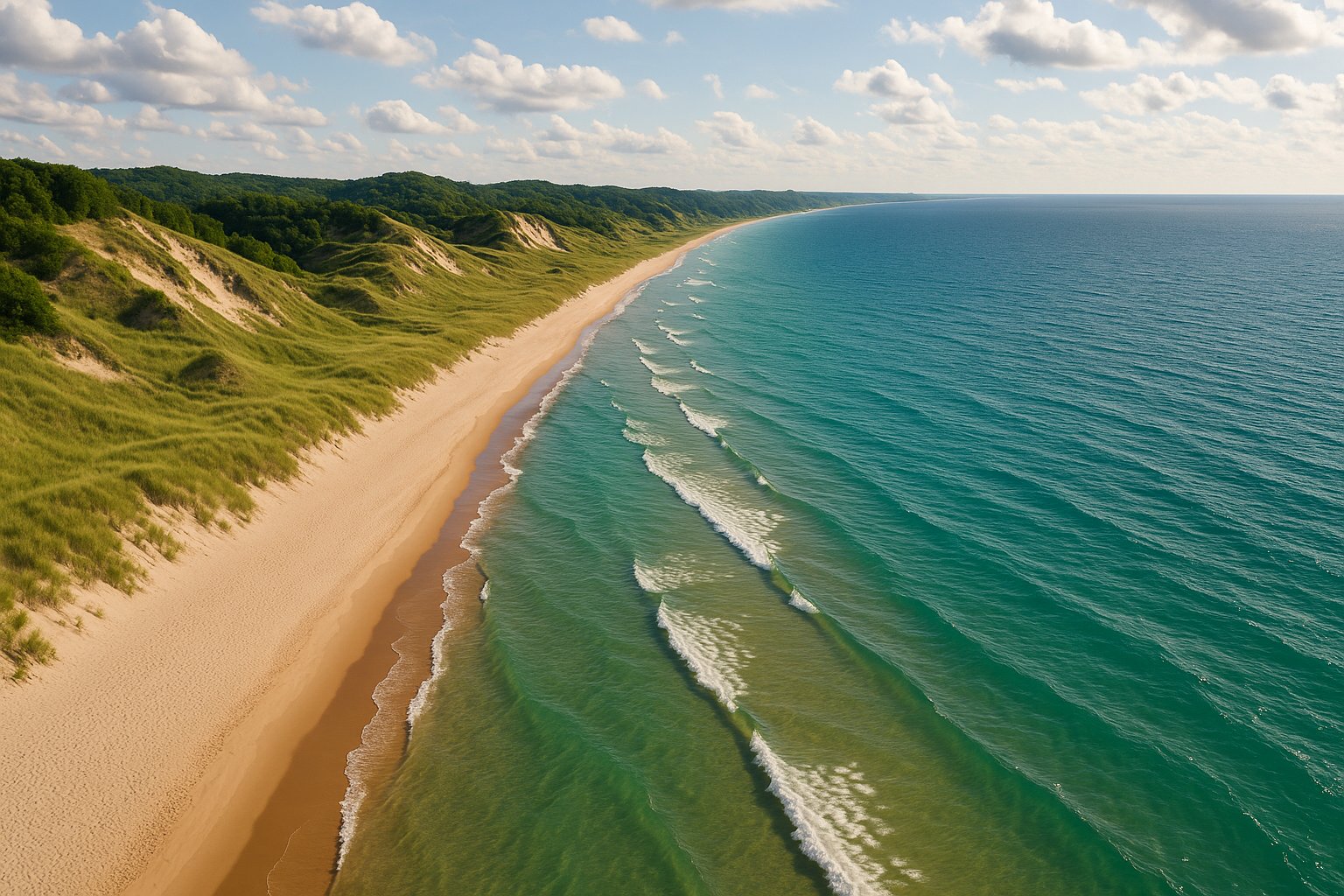
The signature lake for Michigan beach culture. Long, soft-sand beaches backed by dune systems run almost continuously from the Indiana line in the south to the Straits of Mackinac in the north. The water is colder than Lake Erie but warmer than Lake Superior. Most of the state's busiest beach state parks are on this coast.
Village park beach at the foot of the Sleeping Bear Dunes National Lakeshore. Bay-protected so the water warms earlier than open-lake beaches to the south.
Sleeping Bear National Lakeshore. The Platte River runs into Lake Michigan here, creating a warm shallow lagoon ideal for families and tubing.
Wide town beach with the Frankfort North Breakwater Lighthouse anchoring the south end. The Betsie Bay channel divides it from the Elberta beach.
Sleeping Bear National Lakeshore. A small lake sits behind a thin Lake Michigan sand bar. Walk over the bar and you get either side, depending on mood.
Sleeping Bear National Lakeshore. The cannery building and historic village sit immediately behind the beach. Walk west to access the Dune Climb.
Little Traverse Bay shoreline. The state stone, the Petoskey stone (fossilized coral), is found here often enough to make beachcombing a real activity.
At the northwest tip of the Lower Peninsula. Looking west you see open Lake Michigan; looking north you see Waugoshance Point. Quiet, dark-sky friendly.
Long dune-backed sand beach between Lake Michigan and Hamlin Lake. Big Sable Point Lighthouse to the north. One of the most popular state park beaches in the state.
Two miles of Lake Michigan shoreline plus the famous Silver Lake Sand Dunes ORV area to the south. The beach itself is quiet; the dunes draw the crowds.
Big Red Lighthouse at the channel entrance, wide soft sand, full bathhouse and concessions. The state's busiest beach by some counts.
Right next to the Grand Haven pier and lighthouse. Compact beach with high boardwalk traffic, especially during summer festivals.
Two miles of Lake Michigan plus channel frontage. Less crowded than Holland or Grand Haven, with the Muskegon Channel light visible from the beach.
Three miles of undeveloped beach backed by the highest dunes in the lower peninsula. The Gillette Visitor Center has a strong dune-ecology exhibit.
Day-use only, no campground. The walk in from the parking lot keeps the crowds light. Some of the most uncrowded Lake Michigan beach south of Sleeping Bear.
Ottawa County Park north of Holland. A tunnel cuts through the dune to the beach. Smaller crowds than Holland State Park, similar water.
Town beach at the Pentwater Lake channel. The pier at the south end is photogenic. Strong harbor town with restaurants in walking distance.
Three miles of beach with 240-foot dunes rising behind it. The closest big-beach state park to Chicago, so it draws Illinois plates all summer.
At the Black River channel. South Haven Light Station at the south end of the breakwater is a landmark. Wide sand, full amenities.
The southernmost town beach on the Michigan side of Lake Michigan. Closest big-water beach to Chicago and Indiana traffic.
The quieter coast. Saginaw Bay on the southwest side warms earliest in spring and is the most family-friendly stretch of Great Lakes beach in the state. North of Tawas the shoreline gets rockier and more exposed. The Thumb has its own distinct character: dark-sky parks, smaller crowds, and the Lake Huron sunrise that the southern Lake Michigan coast cannot give you.
Lake Huron beach with views toward Bois Blanc Island. Old abandoned lighthouse ruins on the shoreline are a popular hike-to feature.
A long sand point separating Tawas Bay from open Lake Huron. The 1876 Tawas Point Lighthouse anchors the tip. Outstanding migratory bird stopover in spring and fall.
A mile of sand and cobble shoreline between Rogers City and Forty Mile Point. Less developed than the southern Lake Huron parks.
Small day-use beach in town. Heavy cedar canopy behind the dunes. Quieter than Tawas or Port Crescent; favored by repeat campers.
Tobico Beach on Saginaw Bay. The bay is shallow and warms early in the season. Strong birding adjacency at the neighboring Tobico Marsh.
Inner Saginaw Bay beach, fine sand, shallow water for a long way out. Walleye fishery just offshore. Cheeseburger Festival every August.
Caseville-area state park. The beach is on the open bay rather than the inner shallow bay, so it sees more wave action. Mature pines back the dunes. Quieter than Caseville County Park.
A long sand spit projecting into Saginaw Bay between Caseville and Sebewaing. Township beach near the tip. Calm shallow water on the south side, more open water on the north.
Downtown Bay City riverfront park on the Saginaw River. Not a swim beach, but a Great Lakes shoreline space that draws summer concerts and tall-ship festivals. Boardwalk to the Saginaw River channel.
Three miles of beach at the tip of the Thumb. Sandy bottom, often warmer than the nearby outer Lake Huron coast. Dark-sky park designation in 2011.
North of Port Huron on the open lake. Cooler water than Saginaw Bay or the Thumb because the lake is deeper here.
Cold water, dramatic shoreline, and the most consequential weather. Sand beaches do exist (Twelvemile, Bete Grise, Grand Marais) but cobble, basalt, and dune cliff are more common than the long flat sand of Lake Michigan. Visibility through the water column is the best of any Great Lake. The wave climate is also the most energetic; check the buoys.
Two miles of Lake Superior beach on the Keweenaw. Old growth pines, cold water year-round, dramatic sunsets across open lake.
On the Keweenaw east shore. The bay is sheltered, water warms more than open Superior. Famous for the singing sand effect when the wind is right.
At the mouth of the Black River near Bessemer. Five waterfalls upstream make the approach drive worthwhile. Wave action is real here on west winds.
Black Rocks for cliff jumping, Sunset Point for the namesake. Sand and cobble beach along the harbor side. Marquette's signature park.
Pictured Rocks National Lakeshore. Long stretch of remote sand beach, accessed via Twelvemile Beach Campground or hike-in from the North Country Trail.
Pictured Rocks National Lakeshore. The accessible beach near Munising. Pictured Rocks Visitor Center and trailheads close by.
Town beach in protected Grand Marais Bay. Walk west along the shore for the Pictured Rocks Lakeshore Trail.
The Great Lakes Shipwreck Museum, the Whitefish Point Light, and the eastern terminus of the open Lake Superior coast. Migration corridor for birds; staging for the Edmund Fitzgerald loss.
The 1904 Crisp Point Lighthouse stands on a remote stretch of Lake Superior beach west of Whitefish Point. The drive in is rough; the reward is solitude.
Michigan touches only a small slice of Lake Erie at the southeast corner, but it's a meaningful slice for spring and early-summer beach trips. Erie warms first, drops in temperature last in the fall, and the western basin water is shallow enough to feel almost summer-coastal. Sterling State Park is the only state park on this coast.
Michigan's only Lake Erie state park. The shoreline is more marsh than open beach, but the swim area is sandy. Strong birding through the wetland sections.
Small village beach just north of the Ohio line. Concrete pier extends into the lake. Western Lake Erie weather is more variable than the upper lakes.
On a seasonal average, Saginaw Bay (Lake Huron) and the western Lake Erie shoreline warm earliest and stay warmest longest. Bay City State Park, Caseville County Park, and Sterling State Park frequently see swim-comfortable temperatures by late June. Open Lake Michigan beaches lag by two to three weeks. Open Lake Superior beaches rarely become genuinely swim-warm at all.
Michigan State Parks require a Recreation Passport on your vehicle registration (an annual fee added at license renewal). Most city, township, and county beaches are free to walk on but may charge for parking, especially at peak summer beach destinations like Holland, Grand Haven, and South Haven. National Lakeshore beaches (Sleeping Bear Dunes, Pictured Rocks) require a federal recreation pass.
Look for shallow, gently sloping shorelines with low wave exposure. The Lake Huron Thumb beaches (Caseville, Port Crescent, Bay City) and the bay-protected Sleeping Bear Dunes beaches (Glen Haven, Platte River) are the most family-friendly. Avoid open Lake Michigan beaches on days with strong west or northwest winds, and avoid Lake Superior with small children unless conditions are dead calm.
Lake Michigan beaches in Michigan are generally long, sandy, and backed by dune systems. The water clarity is good. Lake Superior beaches in Michigan are more varied: sand at Twelvemile Beach and Bete Grise, cobble and basalt at McLain and Presque Isle, dramatic cliffs at Pictured Rocks. The water is clearer than Lake Michigan but much colder year-round. Lake Superior weather changes faster and the wave climate is more energetic.
Yes, at Sand Point Beach near Munising, at Miners Beach, and along Twelvemile Beach. The water is cold, often below 60 degrees Fahrenheit even in August. The shoreline along the cliffs themselves is not swimming water; it's kayak and boat-tour water.
Several Michigan beaches sit inside or adjacent to designated dark-sky parks. Port Crescent State Park (Thumb), Headlands International Dark Sky Park (Mackinaw City), and Wilderness State Park (Tip of the Mitt) are the most accessible. Whitefish Point on Lake Superior is also a strong dark-sky beach without formal designation. The Northern Lights Michigan guide covers these in more depth for aurora viewing.