Open-Water Ferry Captain & Island Ranger Field Guide · By Chris Izworski
Cross the open water, read the shoals & choose the right archipelago.
Island travel on the Great Lakes is fundamentally different from driving across an interstate causeway. The moment your ferry pulls away from the mainland dock, you enter an ecosystem governed by open-lake fetch, marine fog, strict deck cargo rules, and unforgiving return boat schedules. Whether you are hauling a sea kayak into the wolf-tracked backcountry of Isle Royale or renting a bicycle on car-free Mackinac, success comes down to matching your gear and vehicle footprint to the island’s true personality. Below are 12 field-audited archipelagos across all five lakes, with nautical crossing metrics, dog bans, bike fees, and direct handoffs to our standalone ferry calculators.
By Chris Izworski · 12 verified Great Lakes ferry-access islands evaluated for open-water nautical miles, vehicle and bike regulations, canine biosecurity bans, and direct ferry booking handoffs.
Open-water car ferry crossing · Georgian Bay · Photo: panoramio · CC BY-SA 3.0Car-free historic island · Straits of Mackinac · Photo: August Schwerdfeger · CC BY 4.0Backcountry island wilderness · Lake Superior · Photo: Tony Webster · CC BY 2.0
Interactive Decision Matrix
The Island Personality Matrix
Every Great Lakes island operates under a distinct regulatory and physical regime. Filter the 12 archipelagos below by trip style, open-water crossing requirements, vehicle transport policies, and pet biosecurity rules.
Pan and zoom across the Great Lakes basin. Click any anchor marker to inspect the open-water distance, typical transit time, and skip directly to the destination field dossier.
Freshwater ferry crossings do not behave like ocean passages. The absence of salt density combined with shallow lake basins produces unique navigational hazards every passenger should anticipate.
Wave Period Physics
Steep, Punching Freshwater Chop
Unlike ocean swells that roll on 12-to-18-second wavelengths, Great Lakes waves have periods of just 4 to 6 seconds. When a 25-knot gale hits open Superior or Michigan, it builds steep, vertical walls of water that slam ferry bows rapidly, increasing motion sickness even on large vessels.
Shoal Funnels
Current Acceleration at the Straits
Narrow passages like the Straits of Mackinac, Porte des Morts ("Death's Door" off Door County), and Detour Passage squeeze massive volumes of water between lake basins. Strong underwater currents opposing wind direction create chaotic standing waves and turbulence near ferry harbor channels.
Thermal Inversions
Cold-Water Marine Fog & Upwelling
In May, June, and early July, lake surface temperatures often linger below 45°F while mainland air hits 80°F. This sharp thermal contrast creates dense radiation and advection fog banks. Ferries run on radar, GPS waypoints, and automated foghorns, requiring extra boarding arrival buffers.
Ranger Protocol
The Island Ranger’s 4 Golden Rules of Island Travel
1. The Last Boat Leaves Without You
Ferry captains run strict Coast Guard crew-hour limits. If you miss the final scheduled departure from an unbridged island, there are no road bridges or taxis. You must find emergency island lodging or bivouac safely.
2. Ferry Hazardous Materials Limits
USCG safety rules prohibit passengers from carrying loose camping fuel, white gas, or bear spray into passenger cabins. Camp fuels and batteries must be declared and stowed in specialized exterior hazmat lockers.
3. Glacial Fragility & Alvar Flora
Great Lakes islands host rare alvar limestone pavements, fragile perched sand dunes, and endemic species like Pitcher's thistle. Stay on designated boardwalks; vehicle tires and hiking boots destroy centuries-old moss in minutes.
4. Canine Biosecurity Bans
Isle Royale and the Manitou Islands enforce strict canine bans to protect native wildlife. Domestic dogs introduce canine parvovirus and disturb ground-nesting endangered piping plovers. Service dogs require advance permits.
Field-Tested Archipelagos
12 Great Lakes Ferry-Access Island Dossiers
Each dossier pairs verified nautical distances and open-water swell profiles with ranger access advice, vehicle rules, and direct links to our calculators.
Straits of Mackinac · Lake Huron & Lake Michigan
1. Mackinac Island · Straits Ferry Crossing
Car-Free & Historic
Open-Water Distance4.5 nm (5.2 mi)
Transit Duration16–18 minutes
Departure PortsMackinaw City or St. Ignace
Vehicle PolicyStrictly banned (motor-free)
Bike TransportPermitted ($16–$19 ticket)
Dog PolicyDogs welcome on ferry (leashed)
Mackinac Island harbor arrival · Straits of Mackinac · Photo: P. Hughes · CC BY 4.0
Captain’s Crossing Log:
The passage from Mackinaw City or St. Ignace crosses the deep, high-current funnel of the Straits of Mackinac. Under southwest winds over 20 knots, wave chop builds quickly in the shipping channel. Hydro-jet and catamaran cat hulls provide smooth stability, but lower-deck sheltered seating is smart if you want to avoid spray.
Island Ranger Briefing:
Motor vehicles have been banned on Mackinac since 1898. Over 80% of the island is preserved within Mackinac Island State Park. Bicycles, carriage tours, and walking are the sole modes of transit. Pack a comfortable daypack; rental bikes line the main harbor strip, and the 8.2-mile paved M-185 loop traces the entire shoreline perimeter.
2. Isle Royale National Park · Remote Superior Crossing
True Backcountry Wilderness
Open-Water Distance48–55 nm (56–63 mi)
Transit Duration3.5 to 6 hours
Departure PortsHoughton, Copper Harbor & Grand Portage
Vehicle PolicyNo vehicles (wilderness park)
Canoe / Kayak TransitPermitted on Ranger III / Queen IV
Dog PolicyStrictly prohibited (wolf protection)
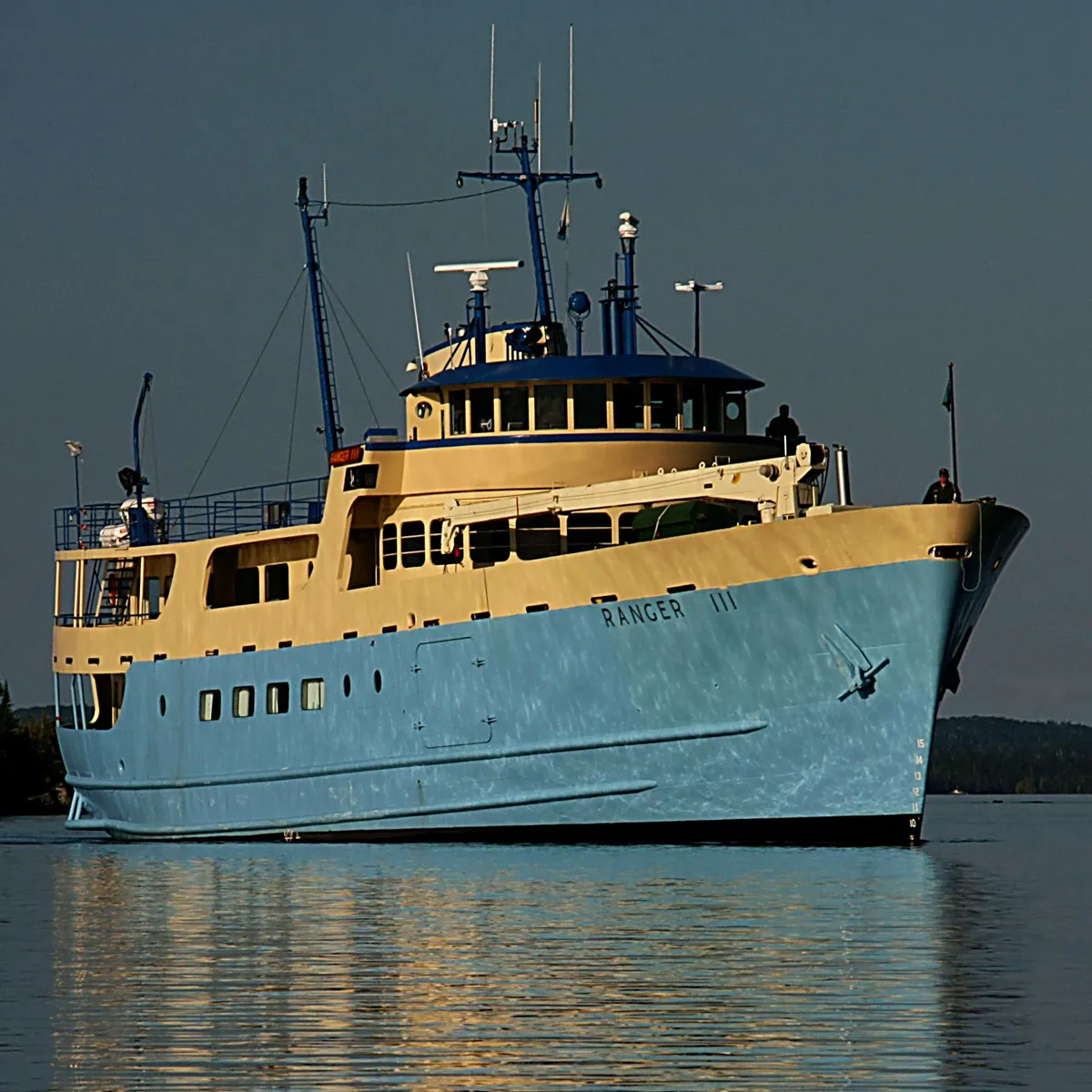
NPS Ranger III open-water crossing · Lake Superior · Photo: National Park Service · Public domain
Captain’s Crossing Log:
This is the longest, most rugged open-water passenger crossing in the national park system. Crossing 50+ nautical miles of open Lake Superior exposes the vessel to deep swells generated across hundreds of miles of fetch. Prepare for rolling pitch; take motion-sickness medication an hour before departure and carry layers for sub-50°F open-lake winds.
Island Ranger Briefing:
Isle Royale is a true roadless wilderness inhabited by wild wolf packs and moose. There are no cell towers, wheeled carts, or bicycles allowed. All hikers must be entirely self-sufficient with water filters, camp stoves, and rain gear. Dogs are strictly barred by federal law to safeguard the fragile wolf population against canine diseases.
Departing Charlevoix requires passing through the Round Lake channel and Pine River pierhead into broad Lake Michigan. The 32-mile open-water transit traverses deep northern Michigan waters. When northwest winds pipe up over 20 knots, expect moderate beam seas. Vehicle tie-down chains are standard on the lower freight deck.
Island Ranger Briefing:
Covering 55 square miles, Beaver Island is the third largest island in Lake Michigan. Bringing a vehicle or sturdy gravel bike is highly recommended to reach remote south-end campsites, the Beaver Head Lighthouse, and pristine inland lakes. St. James provides groceries, taverns, and fuel, but the southern half is pure northern hardwoods and gravel roads.
Sleeping Bear Dunes National Lakeshore · Lake Michigan
4. South Manitou Island · Giant Cedars & Historic Light
True Backcountry Wilderness
Open-Water Distance14 nm (16 mi)
Transit Duration1 hour 30 minutes
Departure PortsLeland, Michigan (Fishtown)
Vehicle PolicyNo vehicles permitted
Bike TransportNo bicycles permitted on island
Dog PolicyStrictly prohibited (shorebird nesting)
South Manitou Island Lighthouse · Sleeping Bear Dunes · Photo: NPS / Wikimedia · Public domain
Captain’s Crossing Log:
Ferry transit departs Leland's historic Fishtown harbor and crosses the open Manitou Passage. South Manitou features a natural crescent bay that offers deep, protected anchorage even when Lake Michigan is kicking up 8-foot waves outside. Note that regular ferry operations depend on dock repairs and NPS seasonal concession schedules.
Island Ranger Briefing:
South Manitou is famed for its 100-foot 1871 lighthouse, the Francisco Morazan shipwreck aground off the south shore, and a grove of old-growth virgin white cedars dating back over 500 years. All travel is on foot. Backcountry campers must register with NPS rangers and carry out all trash.
Sleeping Bear Dunes National Lakeshore · Lake Michigan
5. North Manitou Island · Solitary Wilderness Sanctuary
True Backcountry Wilderness
Open-Water Distance10.5 nm (12 mi)
Transit Duration1 hour 15 minutes
Departure PortsLeland, Michigan (Fishtown)
Vehicle PolicyNo vehicles permitted
Bike TransportNo bicycles permitted
Dog PolicyStrictly prohibited
North Manitou Island shoreline · Sleeping Bear Dunes · Photo: Wade9801 · Public domain
Captain’s Crossing Log:
Crossing the north arm of the Manitou Passage exposes the ferry to northwest swell funneling down from Green Bay. The east-shore landing at the former village dock requires calm conditions for safe passenger gangway deployment. Wind forecasts dictate crossing feasibility.
Island Ranger Briefing:
North Manitou encompasses nearly 15,000 acres of pure designated wilderness. There are no stores, vehicle rentals, or paved amenities. Hikers practice true dispersed wilderness camping (at least 300 feet from Lake Michigan and inland Lake Manitou). Water treatment is mandatory and ticks are prevalent in tall grassy clearings.
Approaching La Pointe dock · Madeline Island · Photo: Oneconscious · CC BY-SA 3.0
Captain’s Crossing Log:
The Madeline Island Ferry Line crosses the sheltered South Channel between Bayfield and La Pointe. Because the channel is buffered by the Chequamegon Peninsula and Basswood Island, crossing cancellations are exceptionally rare during the spring-to-fall operating season. In winter, an windsleigh or ice road often links the island.
Island Ranger Briefing:
The largest of the 22 Apostle Islands, Madeline is the only one not included in the Apostle Islands National Lakeshore, allowing vehicles, private cabins, and paved roads. Drive or bike out to Big Bay State Park to hike dramatic red sandstone cliffs, kayak sea caves, and camp along a 1.5-mile sand barrier beach.
Washington Island coastal bay · Door County, WI · Photo: Yinan Chen · Public domain
Captain’s Crossing Log:
Crossing the famous Porte des Morts strait ("Death's Door") requires navigating between treacherous submerged limestone shoals where Lake Michigan and Green Bay waters clash. Modern ice-breaking steel ferries operate year-round, but northeast gales can create lively roll across the passage.
Island Ranger Briefing:
Washington Island is renowned for Schoolhouse Beach, one of only a handful of smooth, glacier-polished limestone pebble beaches in the world (taking even one stone carries a strict fine). Cycle past fragrant lavender farms, visit the wooden Stavkirke church, or take the secondary passenger-only ferry out to remote Rock Island State Park.
Departure PortsCatawba Island (Miller) / Port Clinton (Jet)
Vehicle PolicyMiller carries vehicles; Jet is passenger-only
Bike TransportPermitted on both operators
Dog PolicyPets permitted on ferries
Perry’s Victory Memorial from harbor · Put-in-Bay · Photo: Nheyob · CC BY-SA 4.0
Captain’s Crossing Log:
Miller Boat Line runs high-frequency drive-on car ferries from Catawba Point to Lime Kiln Dock (18 minutes across 3 miles of sheltered Western Basin waters). Jet Express runs high-speed catamarans from downtown Port Clinton and Sandusky straight into the central village harbor.
Island Ranger Briefing:
Dominated by the 352-foot Doric column of Perry's Victory and International Peace Memorial (commemorating the War of 1812 Battle of Lake Erie), South Bass Island is lively and bustling. Leave your car on the mainland; golf carts and rental bicycles are the universal way to explore winery caves and lakeside state parks.
9. Kelleys Island · Glacial Grooves & Fossil Cliffs
Day-Trip & Bike
Open-Water Distance3.0 nm (3.5 mi)
Transit Duration20 minutes
Departure PortsMarblehead, Ohio
Vehicle PolicyDrive-on vehicle ferry (cars, RVs)
Bike TransportPermitted ($4–$6 ticket)
Dog PolicyDogs permitted on ferry & parks
Glacial Grooves National Natural Landmark · Kelleys Island · Photo: James St. John · CC BY 2.0
Captain’s Crossing Log:
The Kelleys Island Ferry Boat Line departs from Marblehead Peninsula, providing a direct 20-minute run across South Passage. The route is largely sheltered by Marblehead and South Bass Island, making crossings quick and dependable from early spring ice-out through December freeze-up.
Island Ranger Briefing:
Far quieter than South Bass, Kelleys Island features the Glacial Grooves National Natural Landmark—a 400-foot trough of limestone scored 15 feet deep by the Laurentide Ice Sheet 18,000 years ago. Cycle the quiet coastal roads to Kelleys Island State Park, hunt Devonian horn corals on the north quarry cliffs, and explore Inscription Rock petroglyphs.
Departure PortsLeamington / Kingsville, ON (Sandusky, OH)
Vehicle PolicyFull drive-on vehicle ferry
Bike TransportPermitted on board
Dog PolicyDogs permitted on ferry & island
Pelee Islander II at island dock · Lake Erie · Photo: Hadal · CC BY-SA 4.0
Captain’s Crossing Log:
The Pelee Islander II crosses wide open Lake Erie from the Canadian mainland (Leamington or Kingsville) and runs seasonal international sailings to Sandusky, Ohio. Lake Erie is the shallowest Great Lake; sustained 20-knot winds create sudden steep rollers that require vehicle parking brake engagement and deck tie-downs.
Island Ranger Briefing:
Sitting on the same latitude as northern California and Rome, Pelee Island is home to Canada's southernmost winery (Pelee Island Winery pavilion) and internationally renowned Carolinian forest bird migration corridors. Passports or NEXUS cards are required for international travelers. Biking the 18-mile Waterfront Trail loop is the premier island outing.
Drummond Islander IV crossing Detour Passage · St. Marys River · Photo: Corvair Owner · CC BY-SA 2.0
Captain’s Crossing Log:
Operated by the Eastern Upper Peninsula Transportation Authority, the Drummond ferry crosses the swift current of the Detour Passage at the mouth of the St. Marys River. The crossing takes just 10 minutes and runs 24 hours a day, 365 days a year, cutting through thick winter ice when 1,000-foot ore carriers steam past on their way to Lake Huron.
Island Ranger Briefing:
Drummond Island spans 249 square miles—the second largest freshwater island in the U.S. It is famed for the Maxton Plains, the largest intact limestone alvar ecosystem on Earth, featuring rare prairie smoke flowers and fossilized coral beds. A high-clearance 4WD vehicle or ORV is required to access the rugged Marblehead sea cliffs and remote fossil ledges.
12. Manitoulin Island · World’s Largest Lake Island
Bring Your Car & Camp
Open-Water Distance24 nm (28 mi)
Transit Duration1 hour 45 minutes
Departure PortsTobermory, ON to South Baymouth
Vehicle PolicyLarge drive-on car/camper/bus ferry
Bike TransportPermitted ($6–$8 CAD ticket)
Dog PolicyPermitted on designated pet decks & kennels
MS Chi-Cheemaun at Tobermory · Georgian Bay · Photo: panoramio · CC BY-SA 3.0
Captain’s Crossing Log:
The 365-foot MS Chi-Cheemaun ("Big Canoe" in Ojibwe) carries 140 vehicles and 600 passengers across open Georgian Bay from May to October. Crossing between the tip of the Bruce Peninsula and South Baymouth navigates past Flowerpot Island and exposed shoal reefs. Advance vehicle reservations are vital for peak summer weekend sailings.
Island Ranger Briefing:
Covering 1,068 square miles, Manitoulin Island is the world's largest freshwater island, holding over 100 inland lakes of its own. It is home to vibrant Anishinaabe First Nations communities and the iconic Cup and Saucer Trail, which ascends 230-foot limestone cliffs of the Niagara Escarpment for panoramic vistas over hardwood forests and Lake Huron.