Au Sable River
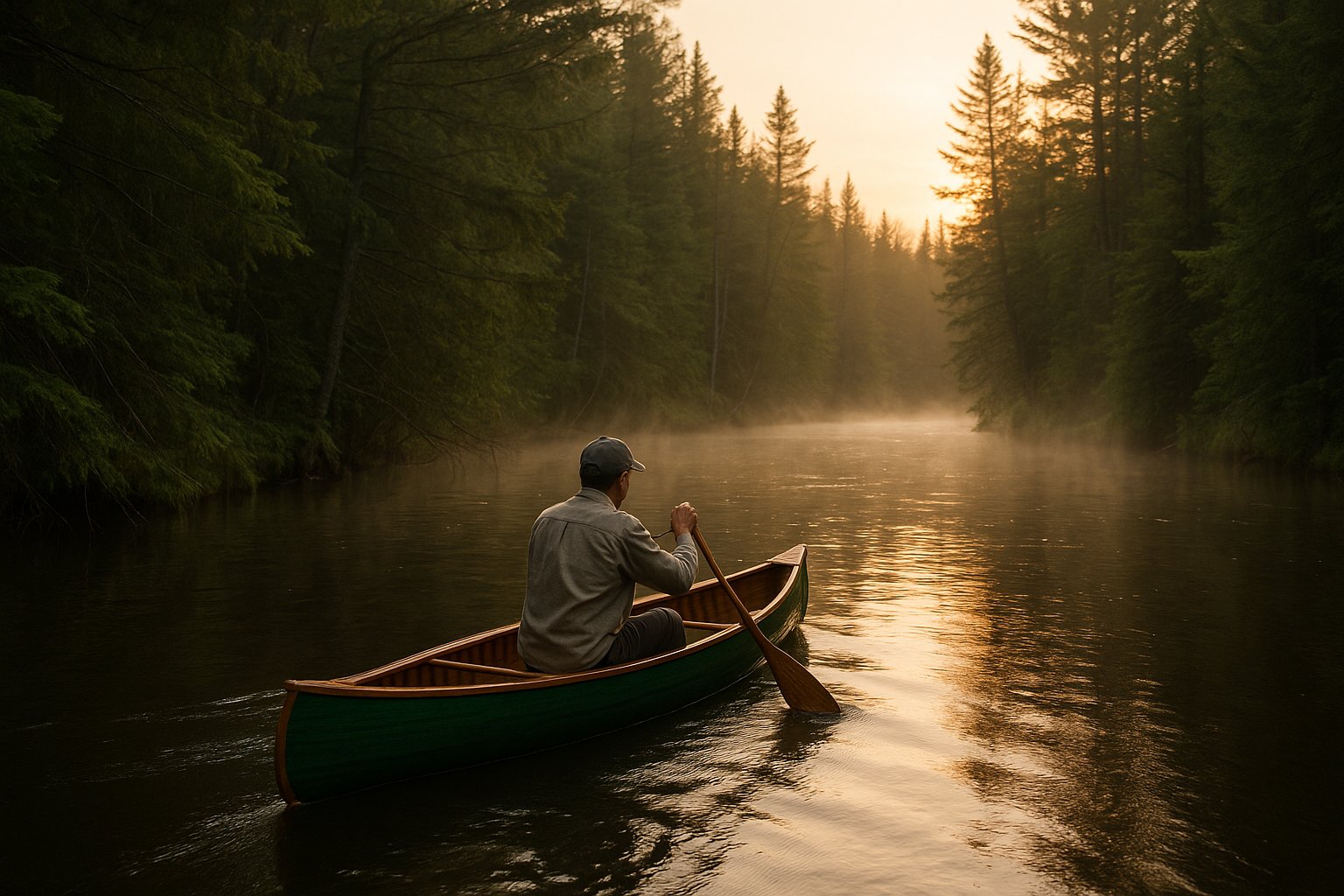
The most famous trout river in the state, designated a National Wild and Scenic River. Heavy livery traffic in summer. Hex hatch peaks in late June. Best paddled outside peak fishing weekends.
A canoeist's guide to Michigan rivers and water trails. Day trips, weekend overnights, and the wilderness routes that take more planning than most people are told.
Michigan has more than 36,000 miles of rivers and streams. A substantial fraction of those are paddleable, and a much smaller but still meaningful fraction are paddled regularly. The classic Lower Peninsula trout rivers, the Au Sable, the Manistee, the Pere Marquette, get most of the attention, and deserve most of it. There are also lesser-known rivers, both in the LP and the UP, that are quieter and in some cases more interesting. This page is the index.
The frame this guide uses is not difficulty class or river mileage. It is intent: are you out for a few hours, a weekend, or a real trip? That distinction matters more than which river you pick. A first-time paddler on the Pine in low water is in over their head; an experienced canoeist on the Two Hearted in fall has a long day at a low pace. The river is rarely the variable that breaks a trip. The plan is.
I write this as someone who paddles wilderness routes in Ontario every year and Michigan rivers in between. The Ontario routes give me a calibration for what Michigan offers and what it doesn't. Michigan has remarkable day-paddling rivers and a small number of multi-day routes that compete with anything in the Midwest. It does not have what Wabakimi has, or what the Albany River system has, or what the Bloodvein offers. If your goal is multi-week wilderness, you eventually cross the border. The framing here is honest about that.
Four useful categories cover most of what people actually do on Michigan rivers.
A livery float is the standard half-day to full-day trip where you rent the boat, the livery does the shuttle, and you put in and take out at scheduled points. This is most of what happens on the Au Sable Holy Waters, the Pine, parts of the Manistee, and the Pere Marquette. It's the right approach for first-timers, for groups, and for anyone who doesn't want to own a boat or solve the shuttle problem.
A weekend overnight involves one or two nights on the river, usually river-camping or staying at established sites. The Au Sable below Mio is set up for this. The Manistee below Tippy and the Pere Marquette flies-only section both work for it. So does the lower Pine, in higher water. The boat-and-gear math is different from a day trip; you're packing for sleeping, eating, and a longer water exposure.
A multi-day Michigan route means three or more nights, typically point-to-point through state forest land or designated wilderness river corridors. The Au Sable from Grayling to Oscoda is the canonical example, even though many people split it into shorter sections. The Manistee from CCC Bridge to Manistee Lake is another. The Two Hearted in the UP for the right paddler is a third. These are real trips with real logistical complexity but still within easy state-forest access.
A true wilderness paddling trip means several days of self-supported route paddling with limited or no road access, no scheduled resupply, and weather that can change the trip. Michigan offers a small number of options that fit this category: the Sturgeon River in the UP, the Pine River in the eastern Upper Peninsula, and portions of the Two Hearted. For everything else in the wilderness category, paddlers cross to Algonquin, Quetico, Wabakimi, or further north into the Albany River and Hudson Bay drainages.
The rivers below are the ones Michigan paddlers cycle through. Each is linked to a dedicated spoke page where the section is built out. Sections without a link are on the build list.
The most famous trout river in the state, designated a National Wild and Scenic River. Heavy livery traffic in summer. Hex hatch peaks in late June. Best paddled outside peak fishing weekends.
The lower river through the Au Sable State Forest. Multiple dams to portage or take out around. Brown trout fishery throughout. The 120-mile end-to-end trip is the closest Michigan offers to a classic point-to-point river expedition.
A federally designated Wild and Scenic stretch through state and federal land. Strong fishery, less crowded than the Au Sable. Tippy Dam tailwater below is salmon and steelhead water, not paddling water.
Michigan's first National Wild and Scenic river designation (1978). Flies-only water in the upper section. Heavy fishing pressure during salmon and steelhead runs.
Class I-II depending on water level, the fastest of the popular Lower Peninsula livery rivers. Permit system in summer keeps the user count managed. Cold water year-round; brown trout fishery.
Restored after the removal of three dams between 2012 and 2018. Quiet, slow current in the lower sections, swift and braided in the upper. Best paddling river within an hour of Traverse City.
Cold spring-fed water, brook and brown trout, federally designated Wild and Scenic since 1979. One of the few Michigan rivers where you'll see no houses for long stretches.
Upper Peninsula. Designated a National Wild and Scenic River, runs through state-forest land with primitive campsites and remote takeouts. The closest the LP-paddler can get to wilderness without leaving Michigan.
In the Pigeon River Country State Forest, the largest contiguous block of public land in the Lower Peninsula. Elk country. Strong brook trout fishery. Less crowded than the famous rivers further south.
In the Ottawa National Forest. Class I-III depending on flow. Long stretches with no road access. One of the few Michigan rivers that consistently delivers a true wilderness paddling experience.
Hemingway's river, the source for the Big Two-Hearted River story. Quiet, brook trout, dense alder. Not a paddle-everybody river; very narrow in spots.
Three things separate a smooth Michigan paddle from a hard one: knowing the water level, choosing between livery and personal boat correctly, and solving the shuttle.
Water levels matter more than weather. The USGS gauge network covers most Michigan paddling rivers in real time. A river that's a comfortable Class I at median flow can become a strainer-filled scramble at low water or a fast-moving brown push at high water. The same Pine River gauge reading that means easy paddling in May can mean dangerous current in October during fall rain. Before any trip on a river you don't know well, look up the gauge, check the historic range for the date, and decide whether the current reading is in the comfort zone or the edge zone.
Livery versus personal boat is mostly about three things: how often you'll paddle, how much you care about boat fit, and whether the shuttle hassle is worth solving. If you paddle a river once or twice a year, the livery is cheaper, simpler, and includes the shuttle. If you paddle ten or more days a year, owning the boat starts to make sense, especially because most paddlers learn fast that a Wenonah Spirit II in Royalex (when you can find it used) or a kevlar tandem from a livery clearance sale outperforms the worn rental fleet on every dimension that matters. If you're serious about wilderness paddling, you own the boat and probably more than one.
Shuttle logistics are the most underestimated part of self-supported Michigan paddling. Two cars at opposite ends of a 12-mile float, drop times, parking lots that fill before noon, and the question of who drives back. Some liveries offer shuttle-only service for paddlers with their own boats. State forest river access points often have less parking than the maps suggest. Plan the shuttle as carefully as you plan the paddle.
Michigan paddling and Ontario wilderness paddling are different sports. The Au Sable lower river and a Wabakimi loop start to look related only when you flatten everything into a category called "canoeing." In practice, they require different boats, different gear lists, different navigation skills, and different mental approaches to a multi-day trip.
Michigan delivers a near-perfect spectrum of accessible paddling. Within a four-hour drive of most population centers, you can find a half-day float, a clean weekend overnight, or a real point-to-point multi-day trip. The infrastructure is mature: liveries, marked campsites, gauge data, shuttle services. You can paddle Michigan well without a heavy gear investment and without sacrificing safety.
Ontario delivers something Michigan cannot, which is unbroken multi-week wilderness routes through some of the largest contiguous boreal-forest paddling country on the continent. Wabakimi, Quetico, and the Albany River system are categorically different. Days between takeouts. Bush-plane access on either end. No marked campsites. Real weather that can pin a party for days. These are not better trips. They are different trips. Anyone telling you the Au Sable is a wilderness river has not paddled the Albany.
The honest answer to where you should paddle is: start where you are. Michigan has more good paddling than most paddlers ever exhaust. If the multi-day routes here start to feel small, the border is a six-to-eight-hour drive.
The Pine River (Lower Peninsula) and the Pere Marquette below the flies-only section are both excellent beginner livery floats: clear current, scheduled put-ins and take-outs, and most liveries provide all the gear. The Au Sable Holy Waters section is also beginner-appropriate from a current standpoint, but the heavy summer traffic can be overwhelming for first-timers on a Saturday.
The reliable season runs from mid-May to mid-October. Some rivers, including the Pine and parts of the Manistee, are paddleable year-round in dry suits, but liveries operate roughly Memorial Day to Labor Day with shoulder weeks on either side. May and September are the best months for the popular rivers: warm enough to be comfortable, light traffic, and prime fishing on the trout streams. June through August carries heavier livery loads.
Most Michigan rivers do not require permits. The Pine River, the Sturgeon River in the UP, and a few stretches of the Au Sable have permit systems during peak season administered by the U.S. Forest Service. Check the relevant national forest website before you book the trip. Permits are typically free or small-fee and exist mainly to limit crowding.
Yes, with restrictions. State forest land along most Michigan rivers allows dispersed camping with limitations on distance from water and on stays per site. National forest land on the Manistee and Pere Marquette has marked rustic campsites. National Wild and Scenic River corridors (Au Sable, Manistee, Pere Marquette, Jordan, Two Hearted) have specific rules; check each before assuming. Camping on private riverfront without permission is trespassing.
The Au Sable River from Grayling to Lake Huron at Oscoda is roughly 120 miles and can be paddled end-to-end in five to seven days, with multiple dam portages or take-out-and-shuttle decisions along the way. The full Manistee from CCC Bridge to Manistee Lake is similar in scope. Either trip is the long end of what Michigan offers without crossing into Wisconsin or Ontario.
No. The Au Sable runs through populated forest country, with houses along significant stretches, particularly in the Holy Waters section. It is one of the most beautiful trout rivers in the country and is well worth paddling, but "wilderness" is not an accurate description. For genuine wilderness paddling, Michigan offers the Sturgeon River in the Ottawa National Forest, parts of the Two Hearted, and short stretches of the Fox. For multi-week wilderness, paddlers cross to Ontario.
For day floats, the livery boat is fine. For repeat paddling, a 16-17 foot tandem canoe in kevlar or T-Formex covers almost everything Michigan offers. Sea kayaks are overkill on most rivers and underequipped on the open Great Lakes. For multi-day trips on the larger rivers, prioritize a hull that tracks well and has the capacity to carry gear without compromising the freeboard.